Going With The Flow At Livermore Falls
Owen Ginty, edited by Mary Ann McGarry
When students at Plymouth State think about Livermore Falls many of us may associate it as a place to swim with friends and jump off risky high places for an adrenaline rush. In reality Livermore Falls is home to much more.
Livermore has been a focal point in the area throughout history because of its geological and other natural characteristics. The geology causes the narrow constriction producing the waterfall which provided opportunities to establish mills dating back to 1700, refer to Figure 1. The falls lie at the junction of three different towns: Holderness, Campton and Plymouth. Where the Pemi forms a cascade is an ideal location to generate power and many have recognized this.

Figure 1. Aerial view of Livermore Falls. Upstream is to the left. Photo by Owen Ginty.
When we look back over time, there are a couple of significant dates. One of the more important is 1759, when the French were defeated in Quebec; borders became more established and this made settling the area of Holderness feel safer, and free of worry of having to be relocated in the future. This was the beginning of development in the area.
Then, in 1771 a gentleman named Moses Little who served as Moderator, selectman, and Justice of the Peace, bought thousands of acres around the falls and built a saw and grist mill. In 1773 the first mill was constructed along the west side of the river.In 1827 Judge Arthur Livermore acquired the property of Moses Little; and renamed the falls after himself.
Thirty-six years later in 1886 a company called Berlin, which is a company out of Connecticut who specializes in iron bridges, built a 263 ft. double span inverted deck trestle which sits 103 feet from the surface of the Pemigewasset River. The existing pieces are the only remnants of what is referred to as the “Pumpkin Seed Bridge,” refer to Figure 2.

Figure 2. The 263 ft bridge for cars sits over the river just below the falls and was closed in 1959. Photo by Owen Ginty.
The bridge closed in 1959; the eastern side was cut loose and dropped making it no longer possible to cross, but this hasn't stopped daredevils from using the bridge as a jumping platform, causing serious injury to some.
A series of mills for different purposes were built at the site and then were subsequently destroyed by fire or flooding. In the 1950’s the mill ceased operation. With the lack of upkeep the mill became a focal point for vandalism. A flood in 1973 washed away part of the mill, further destroying the structure. A dam and power house were taken out by flooding.
Eastman’s White Mountain Guide lists Livermore falls as “wild and romantic scenery”. A Holderness townscape study done by U Conn professors Rudy Favretti and John Alexopolis hailed Livermore Falls as a “priceless natural resource”.
The Wild and Scenic Rivers Act was passed by congress in 1968 to protect certain free-flowing rivers for recreation for current and future generations. The Act’s main purpose was to balance out the nation’s long-standing water resource development policy with river conservation policy. As development along the Pemi continued, a local group lobbied to have the headwaters of the Merrimack designated as a Wild and Scenic River. A study was commissioned and conducted in 1996, but surrounding towns including Plymouth, Campton, and Holderness voted against the designation, but much useful conservation data was collected, .
There was a proposal to build a hydroelectric power plant in 1988 although it was denied by the Federal Energy Regulation Commission after numerous hearings. A key reason for denying the proposal of the plant was that in times of high runoff it could cause flooding upstream 15 miles to North Woodstock.
The hydrology of the Pemi above Plymouth is interesting because there are no retention or flood control dams. Therefore gaging stations are important for alerting people to rising river levels. The first gaging station in NH is located downstream in Plymouth, NH. and another is upstream in Woodstock. Citizens can access real time discharge data to see how fast and high the river is flowing, or as is indicated in Figure 3, that the river is covered in ice: https://waterdata.usgs.gov/nh/nwis/uv?site_no=01076500.
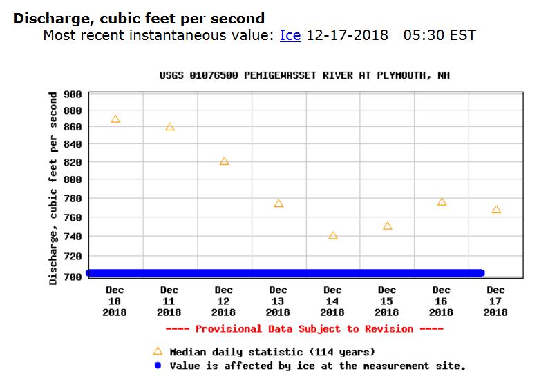
Figure 3. Discharge information from the USGS gaging station in Plymouth, NH, downstream from Livermore Falls, showing ice cover in December, 2018.
Resources
“Campton Historical Society .” Historical Sight Series, Livermore Falls, NH Historical Society, www.camptonhistorical.org/Livermore Falls marker flyer.pdf.
“Pemigewasset Wild and Scenic River Study.” Rivers.gov, New England System Support Office, Department of Interior , Mar. 1996, www.rivers.gov/documents/studies/pemigewasset-draft-study.pdf.
Ruell, David. “LIVERMORE FALLS GORGE: A TIMELINE.” LivermoreFalls.org, Campton Historical Society. http://livermorefalls.org/wp-content/uploads/Historic-Timeline-.pdf